Motto

Anytime, any place there is a storm to chase, that is where you'll find the Hunters of Thunder.

May 27th - Storms aren't Meant to Spin that Way.

Moderate risk, Moderate risk, ooh 5% tornado probability, what looks like nice profiles and good potential in Northern Kansas. When you get there, the storms go up...and the excitement dies when you see the left moving storms tending to dominate. Damn. Typically in the alley the right moving storm is the tornado producer (as the dominant shear profile is anticlockwise, with surface south-easterlies and westerlies or south-westerlies with altitude), the storms for which this area is famous, while the left moving storms are giant hail producers. So it looked like the tornado risk was going to be a bridge to far once more, with relatively high LCLs as well.
The first storm popped up, quickly killed the right mover, and began dropping golfballs. Bit of a disappointment. Not a great start for a day where tornadoes were hopefully on the cards. Storms were moving quickly, so we dropped south for the next cell to form along the dryline.


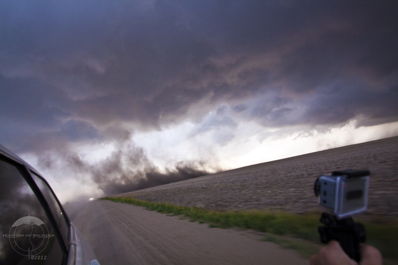
Large hail began falling from the RFD as several funnels became evident.  Photo: Brad.

A white funnel extends as a tumbling RFD carries large hail in our direction and we retreat for shelter.  Photo: Brad.
After trying to beat us up with hail to at least 2 inches the storm moved on and we set our sights on the next cell in the line. We quickly closed on a new left mover, with a few cool solar effects while we drove.
'Atmospheric Yin and Yang' - Shadowing from an updraft to the west creates a dark and light to the atmosphere. Photo: John.

'Reflection' - It seemed no matter how far we ran south, the cells still didn't do what we were looking for. Photo: John.

Finally, we got onto a right moving storm near Ellis, Kansas. Unfortunately, it was LP, but did have some really nice rotation, nice colouration from the sinking sun and some big hail.
The storm rotating structure becomes evident in glorious colour.  Photo: Brad.
Rapid rotation overhead near Ellis, Kansas as a clear slot cuts into the storm.  Photo: Brad.

'Finally Right' - Finally a decent right mover formed without a left mover in the way, unfortunately it was LP, but did rotate strongly and produce giant hail. Photo: John.
Yet another cell formed further south and we chased down onto it as quickly as we could, but the anvil, mammatus in the sunset were too hard to resist over ripened wheat fields with the cell relatively high based. At least we had some great photography opportunities to make up for a moderate risk flop (seems to be a bit of a trend). 

'Sunset Road' - Our road of choice for the sunset with mammatus over wheat fields. Photo: John
'Sunset on Anvil' - The amazing sunset on the mammatus of the anvil of the last supercell in the line. Photo: John. 
And a wide angle pano of the beauty......cos we can :)  Photo - Brad.

Later on we had a terrible tire blowout at night from nowhere and had to limp to Pratt, Kansas. We were hoping that we could solve our issue early enough to make the next day's target. Northwestern Texas was the plan to see what the state where everything is bigger could come up with some reasonable thunderstorm parameters.

May 25th Part 2 - Monsters in the Dark

Its  not often that you have a safe situation to chase tornadic storms in the dark. But with the storms moving very slowly in a single direction, the opportunity presented itself and we decided to drop south after a second tornado near Russell, to the cyclic (producing one mesocyclone after another) supercell near La Crosse, KS. 
 
 
Initially, we were hoping to get lightning illuminated structure, but it quickly became clear that the tornadoes were also revealing themselves periodically under the storm structure, even though the lightning frequency wasn't perfect for what we were trying to do. While we could have gone closer it turns out, for safety sake and to keep us out of danger we stayed a reasonable distance from the storm - but what a show. As we arrived the storm already had 2 tornadoes in progress, a 45 degree stovepipe/rope, and a weaker tornado from the new wall cloud. 
Two tornadoes, a ghostly white stovepipe and a rope extend from two wallclouds simultaneously. Photo: Brad

The two tornadoes persisted for a while, occasionally illuminated by lightning. Photo: Brad.
It wasn't long before a new circulation really got going and the storm began to produce a classic cone tornado which later transitioned into a stout stovepipe. 

The cone tightens in shape under the structure. Note the new wallcloud and mesocyclone to the right of the cone and closer to us, which is the area of next development. The beaver tail extends to the right of frame. Photo: John.

The strong stovepipe, likely just northeast of La Crosse, Kansas. This tornado persisted for some time. Photo: Brad.
The next phase saw another cone plant briefly, but the circulation didn't have quite the same gusto as the previous two.

A brief cone tornado from the next wallcloud circulation, which also produced multiple vortices moments before. Photo: John.

This was followed by a multi-vortex tornado with satellite as the storm moved closer to us.

A large multivortex under the main wall cloud with a satellite rope to the right of frame. This continued the trend of multiple independent circulations within the storm at any one time. Photo: Brad.

The multivortex strengthens while the satellite begins to disappate. Photo: Brad.

Satellite seperates from the cloud base and ground, yet still causes dust swirls while the multivortex continues. Photo: John.

Multiple funnels extend down from the multivortex wallcloud. Photo: Brad.
The storm continued to cycle wall clouds as the circulation planted a seperate trunk tornado from its very low base, while yet another produced an impressive dust swirl under another trunk and a second under a nearby wall cloud. 
A dark trunk extends down from another circulation, contacting ground behind the rise. Photo: John.

Dust swirls rise from weak vortices under the wallcloud on the left, while a trunk kicks up a large amount of dust on the right hand side. Photo: John
The cyclic behaviour continued for one final cycle before the storm finally began to weaken, close to midnight.
The final multivortex and wallcloud. Multiple funnels interact with ground throwning dust into the air. Photo: Brad.

 It definitely goes down as one of the more unique experiences we have had while chasing, though it was disappointing that the supercell structure and at least a few of these couldn't occur during the day - imagine what they would have looked like!

While the 26th was an environment that went to waste (no storms properly formed), the 27th saw us chasing in northern Kansas once more. If you like what you have seen so far, keep up with the latest updates by liking us on facebook, at Hunters of Thunder, and tell your friends.

May 25th - Part 1: Kansas Classic

So finally we were looking at a day with a decent chance at tornadoes. A triple point (the intersection between a warm front and the dryline in this case) was poised to form in northern Kansas, with very potent rotation possible provided storms could make it through the cap. The Storm Prediction Centre stuck to a 5% tornado risk, but noted the probability was much higher in the vicinity of the triple point. Our target was Great Bend, KS with an expectation that storms would form slightly to our NW.

As others struggled to make it back from Wisconsin the day before we had a nice breakfast and a leisurely drive west to Great Bend from Ottawa KS and then waited, chatting to other chasers who had begun to converge on the sweet spot. It took some time for storms to form, but around 5 pm local time the first cell popped and then exploded, hitting 42,000 feet in less than 5 minutes in an environment of 4000 J/kg of CAPE. It took some time to form up and push even higher into the mid-50 thousands, but by the time we had closed on the cell it had rapidly developed low level inflow and a rather interesting wall cloud.

The first supercell of the day with wall cloud and low level inflow tail lifts dust as we close in.  Photo - Brad.
The cell seemed to struggle with the whole rotating wall cloud concept, with stronger mid level rotation, but many small points of rotation in the lower part of the cell. It also produced a very interesting outflow/RFD surge which kicked up tall jets of dust into its inflow and produced a large number of gustnadoes, several particularly strong and this coincided with a tornado report.

The dust machine is ramping up behind us as photography skills are taken to another level!  Photo - Brad.
An unusual feature that was reported as a tornado by other chasers, but may have been a stretching of the spin-up vorticity, illustrated by the vortices within the dust. Photo: John
More evidence of the strength and vorticity in this feature.  Could this be a non-supercellular tornado? Photo - Brad.

Although the cell was looking nice in terms of structure and putting on a dust show like no other, it didn't quite look like it was going to be tornadic at this point. Two other cells had formed to the southwest and eventually we decided to drop onto the next cell and its accompanying wall cloud. We quickly closed again as there were reports of a tornado (unconfirmed) and were treated to a barrage of clean killer CG strikes from the anvil (including one that hit the powerlines 15m away) as the cell intensified before wrapping its wall cloud into the precipitation. 

An unconfirmed tornado was reported while the lightning barrage was incredible on this new supercell.  Photo - Brad.

We repositioned while the storm was cycling a new wall cloud and then observed the circulation increase, produce a rotating funnel and then quickly occlude.

Rapidly formed funnel cloud from an occluded wallcloud area.  Photo - Brad.

However the show was only just beginning as we moved our attention to the next wall cloud.  It began to strongly rotate, dropping an impressive cone which quickly became a beautiful tall elephant trunk tornado, back lit by the setting sun.

'Tornadic Tail' - The tornado extends down from the mesocyclone with a long tailcloud extending to the right. Photo: John


Classic Kansas tornado with sunset.  Photo - Brad.
'Fat Trunk' - The tornado develops an interesting phase with a thick moisture sheath extending high into the storm while pushing southwards. Photo: John
'Elephant Trunk' - After shedding its sheath of fractus, the tornado elongates taking on a classic elephant trunk structure. Photo: John

What a show!  The tornado appears to have swallowed its prey as it bulges out as it rotates.  Photo - Brad.

The tornado transitioned towards a long horizontal rope phase and pushed southwards from the circulation, and appeared to weaken and begin to disappate, only to suddenly re-intensify and extend even further while drilling into the ground.

'Kansas Rope' - The tornado begins to rope out and drill into the surface, or does it? Photo: John

The tornado is still in contact with the ground despite the condensation being cut further up, and up, and up... Photo - Brad.
This show went on for several more minutes as the tornado eventually roped out and our attention turned to a new wall cloud in front of us that would go on to produce several tornadoes after dark including one that would hit part of the town of Russell.

<To be continued in Part 2: Monsters in the Night>