
The chase day 5 started off in Enid, Oklahoma with solid conditions predicted for west central Kansas despite early morning convection. Our target was Pratt, with an adjustment depending on the movement of the triple point and warm front which were the optimal play for tornadic storms. A tornado watch soon followed as cells began to rapidly convect, and finally after watching convection bubble for some hours the storms formed as the triple point lifted north along with the warm front near Great Bend , Kansas where we had repositioned. The chase was on and the storms were moving relatively fast.

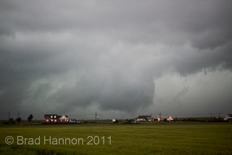
The storm we were on quickly went tornado warned, and shortly thereafter transitioned towards a HP mode and took photogenic expectations to a whole new low. In fact, pretty much our first good view of it was the best of the day.

After that it got, well messy. Typical of larger HPs in a relatively high low-level shear environments there were multiple areas of rotation, and keeping up with the active areas was a real trick. This particular area was producing funnels near Dorrance.

While moving east on I70 we ran into some incredible outflow along the southern flank of the storm, but eventually making it into the bear cage and this gave us a chance to see what the storm was up to. The rotating areas in the bear cage were quite impressive, but not the main focus.


We quickly repositioned east and north as the rain and wind threatened to trap us in the HP, but the roads resisted our best attempts until we got bogged trying to park on the edge of a dirt road that had already been rained on (while getting the car off the highway). After some frantic pushing and skilled work from Feathers we managed to get ourselves out and away from the cage, but before our escaped we saw the below.

Tornadoes on this day were hard to make the final call on, but apparently the one above was a reality reported to the NWS, and we got what appeared to be one in the first phase near Dorrance. This feature produced some interesting behaviour near Minneappolis.The storm was becoming increasingly ugly.
A further low contrast weak white tornado was recorded further east which we saw, but the storm had started to sprint off and was producing large hail (golfballs we encountered as the RFD came round the white funnel) which stopped us keeping up.

All in all a successful chase day, just disappointing it took our equipment to its limits just to show the images above. Good to get our first tornadoes of the trip, we were hoping they would look better though.
Crikey and Feathers.

The storm we were on quickly went tornado warned, and shortly thereafter transitioned towards a HP mode and took photogenic expectations to a whole new low. In fact, pretty much our first good view of it was the best of the day.

After that it got, well messy. Typical of larger HPs in a relatively high low-level shear environments there were multiple areas of rotation, and keeping up with the active areas was a real trick. This particular area was producing funnels near Dorrance.

While moving east on I70 we ran into some incredible outflow along the southern flank of the storm, but eventually making it into the bear cage and this gave us a chance to see what the storm was up to. The rotating areas in the bear cage were quite impressive, but not the main focus.

As the storm moved east towards us we caught sight of an interesting feature to our north:

We quickly repositioned east and north as the rain and wind threatened to trap us in the HP, but the roads resisted our best attempts until we got bogged trying to park on the edge of a dirt road that had already been rained on (while getting the car off the highway). After some frantic pushing and skilled work from Feathers we managed to get ourselves out and away from the cage, but before our escaped we saw the below.

Tornadoes on this day were hard to make the final call on, but apparently the one above was a reality reported to the NWS, and we got what appeared to be one in the first phase near Dorrance. This feature produced some interesting behaviour near Minneappolis.The storm was becoming increasingly ugly.
 h
hA further low contrast weak white tornado was recorded further east which we saw, but the storm had started to sprint off and was producing large hail (golfballs we encountered as the RFD came round the white funnel) which stopped us keeping up.

All in all a successful chase day, just disappointing it took our equipment to its limits just to show the images above. Good to get our first tornadoes of the trip, we were hoping they would look better though.
Crikey and Feathers.
No comments:
Post a Comment