Motto

Anytime, any place there is a storm to chase, that is where you'll find the Hunters of Thunder.

Short Analysis of the Black Ranges Tornado, Victoria, May 24th

On May 24th there was a tornado observed near Stawell in the Black Ranges, Victoria. I generally like to keep track of local happenings, and this particular event took my interest.


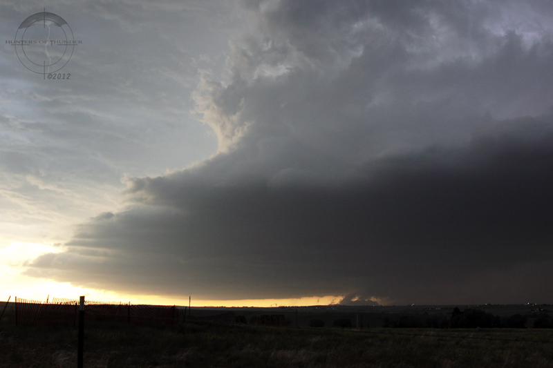
A photo of the tornado from a local resident. It was accompanied by hail. Photo Source: Stawell Times
Further details of the observation can be found here: Stawell Times
http://www.stawelltimes.com.au/news/loc ... ?src=email

A radar loop of the event can be found by clicking below, note the cell near Stawell and Ararat between 2pm and 5pm local time.
http://www.theweatherchaser.com/radar-loop/IDR022-melbourne/2012-05-24-01/2012-05-24-10
Based on radar analysis, it looks to me to be a left moving type supercell storm ( intially I had my doubts and thought it was right moving intially), but if you look carefully between 2pm EST, and 4pm you can see the cell actually move left of the mean flow from Stawell to Ararat. It seems like the cell initiates around 2pm, and disapates/gusts out around 5pm after generating a right split. Three factors therefore convince me this was a supercellular tornado - longevity, deviant motion from mean flow and splitting behaviour. There is also some indication from the eyewitness that the storm was very much tornadic, with the tornado not being that short lived : "Then suddenly it deviated away to the right, broke down and formed another small twister in a neighbour's paddock.", this would suggest an unstable vortex phase or possibly a second tornadic circulation. From the lifting/damage described (particularly trees ripped out and moving the toolbox) I would estimate it was probably an F1. There is also some indication that largish hail was also present within the storm given the mentioning by the resident, and this was likely a result of the supercellular processes at play (which with extremely cold uppers can overcome the relatively low instability).

The maximum temperature on the day was 13.9, but a 3pm observation at Stawell aerodrome gives a 11.9 degree temperature with 85% RH and southeasterly surface winds and a surface pressure of 1011.7hPa. A quick look at the synoptics suggests an incipient low pressure system located in NW Victoria as of 00UTC, with a trough to the southeast, forming in the preferential post-frontal air mass (typically the unstable airmass following a frontal passage on the equatorial side will lead to secondary cyclogenesis).


By 06UTC the surface low had deepened to 1009hPa suggesting cyclone intensification and a slight move to the Southeast.


Checking the radar we also can identify that the cells death was preceded by a shift of wind direction at steering level to northeasterly while prior to this motion was front the north. Based on the trough observation from analysis, and this behaviour we can conclude that the cell was initiated by the trough, and developed in a favourable pre-trough regime (almost warm-front like from the moisture observations).

Looking at the upper air information at 00UTC:
700mb:


500mb:
This tells us that the environment was characterised by steep lapse rates, with temperatures of 11.9 at the surface, 0 degrees at 850hPa, -9 by 700hPa and -30 by 500hPa. (note this was about 4 hours earlier so lapse may have been greater). I've been unable to get my hands on an upper air sounding due to the university of wyoming being down, but Melbourne wouldn't be particularly representative anyway due to its position relative to the front and the different flow (noticeable on radar). Based on a little work with my spare skew-t (have a laminated one in my office), I would estimate that LIs were probably  in the range of -1 and -2 between surface and 700mb, and CAPE would have been sub 200 J/kg. Given the extremely cold uppers and the local low, It would also seem that the storm tops were not particularly high.

The shear characteristics are very hard to work out without an upper air sounding, but the radar and surface observations give some clue. Surface observations were southeasterly that fits with the presence of the trough as the initiating boundary, and is also the direction the storm ended up moving, and hence the cell likely enhanced its storm relative helicity (tendency to spin) by doing so. General motion of cells without deviant behaviour was to the south, suggesting overlying northerly flow. Motion of cells not deviantly moving was of the order of 25-30 knots which would suggest at storm steering level (around 700mb) that we had 25-30 knot northerlies at least, possibly more. Overlying shear was probably much stronger given the type of environment, and a quick look at 300mb yields:

A strong northerly jet on the lee side of the developing cyclone. Based on this information, we therefore know we had an environment highly conducive to left moving supercells, with turning from SE to Northerly shear vectors producing useful helicity to any storm that developed.

This leads me to my final analysis: This event was a cold core tornado that was produced by a reasonably long lived, left moving, low-topped supercell in a low instability, highly sheared environment. The environment for the cells lifetime was characterised by high relative humidity (85%), low instability (sub 200 J/kg CAPE, but -2 LIs in the 0-700hPa lift), and reasonably high cyclonic shear (likely in excess of 50 knots). These conditions are perfect for the development of low-topped supercells, and given the relatively low LCLs, turning within the cell along with helicity increases due to motion into the surface inflow, and low level instability associated with high lapse rates, it is little wonder that it produced an F1 tornado. These systems are relatively typical for postfrontal airmasses or in the vicinity of low centres in southwestern Victoria (See Coloquhuon et al. 2008 and other studies).

If you are interested to know more, please leave a comment or question.
John

Acknowledgements: The Bureau of Meteorology for synoptic analyses, The Weather Chaser for radar loop and the Stawell Times for the photo.

June 7th - Collosal Colorado, rinsed and repeated.

After playing with a tornado warned storm and the largest quantity of hail (over such a large area) I have ever seen the night before I began my day in Denver happy in the knowledge that I was likely to see a repeat showing of slow moving storms with possible tornadoes, large hail and most importantly supercell structure!  For the second day running, the Denver cyclone and converging winds off the Palmer Divide would not dissapoint.

It appeared to me that there were two legit targets for the day; one in the NE corner of Colorado and pushing into SE Wyoming where easterly surface winds and relative high dew points in the mid to high 50's were being drawn in by the Denver Cyclone effect, while the second target was the Palmer Divide where storms often fire and move east or south east into the plains.  I decided to play the NE target first where storms were likely to fire earlier and see if they became tornadic before heading for the south target once things got messy up north.  I moved to Fort Morgan once again but before I finished the 90min trip from Denver, a tornado watch was issued for the area and a storm in SE Wyoming (about an hour to my north) was already showing signs of producing a tornado (which it did).

Sure enough storms fired to my SW and I moved to intercept south of Wiggins where I saw early and brief signs of supercell structure and got hit by golf ball hail and torrential rain as I core punched several times.  The storms in the area were again moving NNE like the day before and radar showed some strong rotation in the upper and mid levels and it seemed the storm may go tornadic however it split and the preferred right split did not survive with the left split dominating leading to low visibility and a lot of rain = no fun.  In the meantime storms were firing off the Palmer Divide about an hour to my south so I made the same decision as the day before to abandon the NE mess and head south.

The main storm of interest soon became a supercell and dominated its environment and I recieved messages from John regarding its behaviour on radar and reports of rotating wallclouds and funnels as I drove......with purpose.

Once I closed on the storm from the NE I could see the tell-tale signs of a monster supercell that was going to be worth the effort and I quickly gained position on the interstate to the west of Limon as the storm moved south at 5-10mph.  Similar to the day before I could see the base, wall cloud and interesting lowerings on the forward flank to my west. 


The first view of the low base features to my SW near Agate, Co.  Photo: Brad.


Surface interaction was evident as the forward flank produced weak funnels and kicked up dirt.  Photo: Brad.


Today I decided to go straight at the monster and get close so I went west to within about 500m and then paralleled the storm southward with incredible views of the most intense broad rotating structure I have ever seen up close. And then there was the beaver tail and 100km/h inflow winds to boot. Wow - what a storm, and I knew that the mid level and upper structure was likely epic from a distance but you cant be in two places at once. Photography and video was difficult do to my proximity and the insane inflow that made it difficult to stand upright but you get the picture from the shots I did get.


Direct intercept! heading west at the slow moving supercell.  The beaver tail is developing above me as a ghostly white lowering can be seen in front of me.  Photo: Brad.

The broad rotation of this storm was something quite amazing.  The white low level cloud in the photo below was ripping left to right around the storm so quickly, hopefully I got some video of it amongst the chaotic wind and excitement.


Awe inspiring low and mid level structure at this stage with 100km/h inflow and incredible broad rotation up close now.  These are wide angle shots! Photo: Brad.

I was so close to the storm now that only wide angle lenses could begin to capture it and even then it required panoramic photos and stitching software to begin to do it justice.  It was a challenge to photograph due to the conditions but below is a crude stitch that gives some idea of the structure.
Stitched wide angle panoramic (5 shots) to demonstrate the structure. Note the 2 wall clouds and RFD.  Photo: Brad.

As I drove south in parallel with the storm a strong persistent cone funnel emerged to my west but I was unable to confirm a tornado myself despite other reports in the area.


A possible tornado to my west but I couldnt confirm touchdown from my position.  Photo: Brad.


I found my way south to a west road and went closer again, this time with 100m of the advancing hail shaft that was now an irridescent blue colour and contrasted with a magnificent, strong bright white beaver tail almost overhead, that was intersecting the mesocyclone from the east. You dont get much closer to the business end of a monster HP supercell than this - without getting smashed by large hail or a tornado. I allowed the storm to advance on me until the last moment where I had my GoPro wide angle camera mounted on the back of the car and then I fled eastward for a south road.


Beaver tail!!!! moist easterly inflow feeds directly into the mesocyclone as the core advances on me west of Limon.  This stitched pano is comprised of 7 wide angle shots and that core is only 200m away!  Photo: Brad.


I was less then 5mins into my east move when I just had to see what was behind so I took a shot out the window and was so blown away by what I saw on my screen I had to stop right there!  exposed ringing supercell structure all the way into the upper levels and a clear view of the beaver intersecting the mesocyclone. Add to that the menacing dark shadows under the storm where I had just come from and it was a chasing moment I wont forget.
Okay, so picture this....Im bailing east to avoid getting smashed and I turn to look out my drivers window to see this behind!
Photo: Brad.

Wide angle stitched pano (7 shots) west of Limon.  Photo: Brad.
I finally hit a south road and blasted along to get into position for the final moments of light as the supercell took it's exposed structure to Another Level (yes that does have a meaning).  The beaver tail from the east was one of the longest I have ever seen (the extended length is not captured in these photos) and the exposed mesocyclone at sunset was simply extraordinary.

Just about speechless at this point.  Structured supercell with monster beaver tail at sunset north of Rush.  Photo: Brad.

Okay, speechless now!  Photo: Brad.

Colours and a new tornado warning on sunset, stitched pano taken near Rush.  Photo: Brad.

The supercell continued its incredible rotation after dark and made several attempts to tornado with sunset backlighting.  Photo: Brad.


The supercell continued slowly on its way south and was again tornado warned (and for baseball hail) just after sunset as it's incredible rotation continued.  I witnessed several wall clouds and areas of focussed rotation after dark near Rush, with lightning illuminating the structure and one weak funnel.  Eventually I called it a night and headed toward Limon for data and to make some big decisions about the remaining days of my chase trip.


June 6th - Fried rice with cashews, tornadoes and a Colorado classic

After dropping a subdued John at Denver airport and checking the models and SPC forcasts, it was very clear I would be targetting the front ranges of Colorado the next day so I headed for Fort Morgan for the night and some Chinese fried rice with cashews.

The morning of the 6th saw me in a 5% tornado risk area before I even got out of bed!  There was a Denver cyclone developing and combined with upslope flow and the potential for storms to fire off both the Palmer Divide and the Cheyenne Range, the day was looking full of promise.

So, as you do when you are already in your target area at 10am, I headed off for fuel, food and a Maccas to pass the time until storm initiation.  After several hours of not seeing any other chasers in town, the convergence began including several doppler on wheels radar units and research teams.

Eventually storms fired to the west nd were moving slowly NNE.  I held back within view and watched radar as others raced north but I was unimpressed by the storm motion and what I was seeing.  I was waiting for a right mover or a cell to break away from the NNE motion and feed on the easterlies being pulled in by the Denver cyclone.

After following the initial cells slowly north I decided that the only sure bet for supercells this day would be to take a punt on cells developing an hour or so south off the Palmer Divide so I turned my attention that way and drove south for an hour.....and what a decision!  As I approached my revised target area and had a slowly south moving storm in view, I was alerted to a tornado warning to my SW near the southern outskirts of Denver and another chaser convergence was underway including the Dominator tornado intercept vehicle and support vehicles.

Soon I was in position to see the solid base features and dynamic nature of this supercell which persistently produced funnels and lowerings on the forward flank as it was really getting ramped up.  I captured a possible brief and distant tornado (perhaps a landspout) in this early stage as the storm structured up, developed a long inflow tail from the east and went nuts on the moist easterly inflow. 


The first view as I head south onto the near stationary supercell with solid RFB and forward flank lowering.  Photo: Brad.

This possible tornado (or landspout) was persistent & one of several early features on the forward flank of this storm.  Photo: Brad.

Not long after I noticed a large wall cloud area organising to my west and a clear slot was evident cutting around it. 
Structure!  The storm was barely moving but had impressive inflow from the SE as a wallcloud forms.  Photo: Brad.

Sure enough, a tall elephant trunk tornado formed right next to the wall cloud (but not from it) and was on the ground for over 5mins. Interestingly, as the tornado roped out and lifted the wall cloud area seemed to grow larger, take on a cone shape and lower toward the ground. To me it appeared to be a large cone tornado and perhaps even a wedge. To further enhance my thoughts on this being another tornado, the entire area finally lifted and what I thought initially was a wall cloud went through a significant rope out and I have never seen a wall cloud rope out before........... interesting.

The storm produced tornadoes, flash flooding and then simply ridiculous amounts of hail as it moved ever so slowly over the next few hours.

A tornado is forming as a clear slot cuts around the dark wall cloud area.  Photo: Brad.

A tall elephant trunk tornado persisted for over 5mins to my west as I was driving south for position. Photo: Brad.

The tornado begins to rope out but is still quite large while the clear slot is cutting further around the adjacent wall cloud.  Photo: Brad.

Spectacular structure as the entire wall cloud area is now roping out which leads to a few questions..... Photo: Brad.

Wow!  Mammatus clouds on the forward flank of the storm were persistent like this for over half an hour!  Photo: Brad.

Large areas of dust/dirt were lifted into the storm base to my west.  In this case a large funnel is curving back into the storm.  Photo: Brad.

I eventually core punched the storm into southern Denver and had fun with the crazy hail drifts for a few hours before chasing a new tornado warned storm through the SW suburbs at midnight! I saw the wallcloud and obvious signs of rotation on this storm lit up by city lights and constant lightning before this storm turned into yet another slow moving hail machine that turned the suburbs into a land of white ice like i've never seen before. At one stage as I core punched the hailer through a technology and business park, I came across rescuers who were pulling other cars out of several metres depth of ice and they told me they had already rescued 7 others. There was nothing I could do to help as the roads around me became rivers so I turned around and called it a night.

Later that night, Denver's SE was smashed by near stationary severe storms and ridiculous hail quantities.  Photo: Brad.

After chasing all day, how about a tornado warned storm in Denver at midnight?!?!  Photo: Brad.

A quick check of data for the next day showed that I wouldnt be going far.  Could Colorado do it two days in a row?  Of course it could!  ........and even better :)

May 29th - Oklahoman Wonder

After a bit of a disappointment in Texas the previous day, we set our sights on Oklahoma where a good environment for supercells appeared to be in the offing. With strong deep layer shear, and moderate to strong instability combined with reasonable dewpoints, tornadoes were a chance and structure would hopefully show itself. We targeted El Reno, OK, and sat in the incredibly oppressive conditions - 100F (38C) with mid 60 degree farenheit dewpoints for some time waiting for the southernmost storm to get its act together. Eventually the storm transitioned from a more multi-cellular appearance into a nice supercell, which we closed in on as it structured up.  Wide angle lenses were the order of the day from here on in!

'The first view' as we approach from the south and then flank the storm to the east to get into prime position.  Photo: Brad.

'Barrel Ahoy' - The structure reveals itself from the murk as the supercell begins to structure over the fields near Loyal, Oklahoma. Photo: Brad.
And what a structure! 3 tiers and exposed to the world with the fields of Oklahoma stretched out below it. One of those simple wow moments that you just love to have when chasing!

'Wedding Cake' - A classic 3-tiered supercell mesocyclone reminiscent of a wedding cake floats like an impossible creation over the plains. Photo: John.
Wow!  Says it all really.  Photo: Brad.

The rotation speed within the storm was insane, almost dizzying with multiple areas of strong rotation and a closely proximal anticyclonic rotation as well. We went in relatively close (at the expense of structure) for the chance at a decent tornado when the wallclouds came down, but unfortunately early on the storm remained relatively high based and only produced a few weak spinups that were confirmed by other chasers as 'tornadoes'.

'The First Attempt' - Strong elevated rotation but not with the wall cloud to match, the first strong attempt at a tornado manages to generate some weak surface circulations. Photo: John. 
'Another Lowering' - The supercell continuously cycled, with RFD cut being followed by yet another strongly rotating wall cloud a number of times. Photo: John
Racing south to keep position, this was the view from the drivers seat! Photo: Brad.
What was far more impressive was the size of the hail being produced by the storm, hailstones were reported to Grapefruit size (5", 12.5 centimetres), with some allegedly up to 6 inches! Fortunately we managed to keep ourselves out of trouble with the gorilla hail core (though 3 inch stones smashing on the road and bouncing over the car were a little close for comfort), and kept good position on the cell for a couple of hours, until it decided to go bananas upon collison with a left moving supercell near Piedmont, on the outskirts of Oklahoma city. The result was an incredibly structured new cell with strong rotation that produced a weak tornado and some pictures that I don't think we will ever forget. 

Tornado! Dust is raised as a dark funnel emerges near Piedmont north of OKC.  Photo: Brad.


'Wrapped In' - The tornadic circulation is quickly wrapped within the monsters precipitation. Photo: John.

'In full flight'. The beast is capable of producing tornadoes and at least grapefruit size hail. Photo: Brad.
'A Monster Unleashed' - With the impetus it now needed to go ballistic the new supercell quickly went HP and wrapped its core circulation while producing a tornado. Note the unusual filtered halo on the right. Photo: John.
'Greenage' - The sinking sun and the giant hail within the storm gave an interesting optical effect in producing the most eery green glow through the clouds. Photo: John.

Chasers become the chased.....by giant hail!  The view behind as we run.  Photo: Brad.

We then proceeded to play with the hail cores on the western edge of Oklahoma city as this cell and numerous others trained over the area. We encountered a few stones above tennis ball size, but unfortunately couldn't catch the grapefruit producer through the metro.

'Decay' - With the excitement of the collision now over the cell quickly ran into an unfavourable environment and fell apart in front of our eyes on sunset. Photo: John.
'A Certain Kind of Light' - The lightning didn't really happen for us on this day, but still offered some interesting photographic opportunities if you knew where to look. Photo: John.
 All in all a fantastic days chasing, and exactly what bring us to the states effectively the 'tail-end charlie' and amazing photo opportunities with a gorgeous storm. Still looking for that amazing tornado though.

May 28th - Texas Dust on New Rubber

The Memorial Day holiday started out with sunny skies in Pratt, Kansas and Brad's unlucky and now annual pilgrimage to Walmart Tire and Lube for a new tyre and a leak repair for another.  Thankfully it was quiet and I was first customer so by late morning we were on the road south through Oklahoma with our target being Vernon, Texas.

Parameters looked reasonable, with CAPE (instability) looking high for the day well into the 3000 J/kg range, with shear 30-40 knots over the 0-6 km range storms looked like going HP but there was the chance for some structure. The tornado potential looked relatively low with surface temperatures approaching 100F and 60F dewpoints meaning the spread was too large.

We intercepted the first storm of the day near Seymour, Texas and watched it form a solid rain free base and throw down some impressive daytime CG strikes, some pulsing enough to be photographed hand held.  The storm looked to be structuring up well but we were expecting it to go HP (high precipitation) and this storm mode can be hit or miss when it comes to being photogenic.

'Texas Supercell' - Red dirt, aqua hail cores and big as HP storms. Welcome to Texas. Photo: John.

A storm is consolidating it's rain free base and producing a CG barrage near Seymour, Tx.  Photo: Brad.
We repositioned south and east to keep in front of the storm as it was going HP and witnessed some awesome blowing red dust which made driving even more hazardous at times.

'Wall of Dust' - Punching into the unknown and through gustnadoes within the inflow and outflow dust  to try and get position on the now HP storm. Photo: John.

Red dust races across our path and at times cut visibility to 5m!  Photo: Brad.

Vorticity certainly was not in short supply as we stopped to enjoy an incredible view into the eye of a local area of rotation almost directly overhead. 

Rapid rotation directly above us was incredible to see.  Photo: Brad.

Several strong storms were now in progress with little seperation so decisions had to be made which one we thought would have the best chance to thrive. We continued to position east and south hoping the storms would answer that question for us as but they were playing games!  Two storms were producing wall clouds simultaneously with us located between them.  The one to our east produced the most convincing funnel of the day, albeit short lived while the original storm stretching from behind us and to our north tried and tried again but never really looked like producing anything more than a few half-baked funnels from several wall clouds.
Two storms were producing wall clouds within our view; this one to our east produced a brief funnel.  Photo: Brad.
A wall cloud to our north looked good, then didnt, then did and produced a brief funnel shortly after this.  Photo: Brad.

We continued to position near Graham, Texas but as daylight faded we positioned for hail and wind as the storms moved across.  

'Dark Squall' - When we positioned for wind and hail the storms weakened and offered little photographic opportunity. Photo: John.

As tends to happen on weakening supercells and after the rain has passed, we were treated to a great but short display of lightning including some crawlers and a rare opportunity to capture 'up lightning'.

'Up lightning' - a rare sight, this bolt was captured near Graham, Tx.  Photo: Brad.
'Twice the Bolt' - Lightning can get a little boring so it was time to get a little creative. Photo: John.

The next day saw us chasing in Oklahoma, hoping for the chance at another tail-end charlie storm in what looked like a nice environment for supercells.