Motto

Anytime, any place there is a storm to chase, that is where you'll find the Hunters of Thunder.

May 21 – Hiawatha HP – Sky boobs, tornadoes and sirens in the dark.

After the highs of Greensburg the previous day and sleeping at Wichita KS overnight the chase took us to northeast Kansas, north of Topeka. Two really nice cells formed on this day, one southwest of Topeka, and a second southwest of Hiawatha. We chose to pursue the northern cell and were rewarded with another good days chasing, some awesome mammatus (AKA Skyboobs!) and a few tornadoes under an open structured HP type supercell. We started south of the cell, and raced north and intercepted it as it matured near Hiawatha.

The cell showed a powerful signature on radar as we approached and was warned for Tennis Ball hail (and not just warned, observed by some people who got a little too close). Thanks to some roadwork it took a race against the wrapping of the RFD (Rear Flank Downdraft) and the hail core of a second cell to the south to get on the right side of the storm.


The punch paid off, and we found ourselves in an excellent position, in time to see the storms first tornado under a nicely structured base.  


A quick reposition across the Missouri River and we got to see an impressively structured wall cloud, and the pursuit continued across the hills of northern Missouri. 


We were back on it for the second tornado north of St Joseph as the storm appeared to structure further. We continued to follow the cell east until dark, and observed another weak tornadoes before the storm dissipated. 


This wasn't the only drama though, as just because the sun goes down the storms don't stop. Tornado warned storms in a complex structure were coming rapidly from the west, and we were forced to drop south with the prospect of tennis ball hail from many of the storms. We came through Kansas city on the edge of another cell. 


We were pumping fuel and contemplating our next move when overhead a haunting siren sounded, chilling us to the bone.  When you hear one of these on video you will understand how eery these things are at night...pretty scary if you don’t know what is out there. We decided the safest course was not to be in Kansas city with tornadoes bearing down and quickly skirted south, getting a view of the first incoming cell illuminated by lightning(which fortunately dissipated coming into Kansas city, a greater metro of around 2.1 million). We were observing radar at the time, and seeing three training monster supercells with tornadoes on the ground or potential to produce them was surreal, one of these cells produced an EF3 tornado which did significant damage to Reading, KS. We managed to stay out of trouble and ended up in Wichita for the night once more.

Crikey and Feathers

May 20 - Greensburg Gold

This is the sort of day that a photographer dreams about. Outstanding colours, gorgeous structure and slow moving supercells. Original target was between Pratt and Greensburg, and the storms had little risk of becoming tornadic with a weak low-level shear profile, but still provided the most photogenic day of the trip, and one of the best we've seen in the states. While we had a huge number of shots from this day, we have only chosen a sample of the top shots for brevity. Our chase target was rewarded with us being amongst the first on the nice supercell which formed SW of Greensburg.


The amazing thing was, it was only a taste of things to come. The second and third supercells were also photogenic (though they couldn't even make either of our top 4s), and as the hordes of chasers descended they were drawn away by the earlier cells moving northeast. As the cells moved into this environment they became more outflow dominant, and we dropped onto the southernmost cell (4th supercell and the storm of the day), which turned out to be the best of the lot.


The supercell's base was separated from the rear-flank downdraft and foward flank downdraft  such that you could drive between them, offering a unique view of many of the features of a supercell that you rarely get to see (without driving into a tornado or copping the really big hail).


It left us unconcerned that we were behind the storm, knowing that if somehow the storm managed to go tornadic we would see what was going on.


The photographic opportunities only improved as the sun got lower, and we were rewarded with a sunset that was beyond belief, and these two shots from 'feathers' show the closest thing to being there, we only wish you could have seen it.


A grand day for photography, and one that will be etched into our memories for many years to come.

Crikey and Feathers

May 19 - The Dorrance Dog

The chase day 5 started off in Enid, Oklahoma with solid conditions predicted for west central Kansas despite early morning convection. Our target was Pratt, with an adjustment depending on the movement of the triple point and warm front which were the optimal play for tornadic storms. A tornado watch soon followed as cells began to rapidly convect, and finally after watching convection bubble for some hours the storms formed as the triple point lifted north along with the warm front near Great Bend , Kansas where we had repositioned. The chase was on and the storms were moving relatively fast.


The storm we were on quickly went tornado warned, and shortly thereafter transitioned towards a HP mode and took photogenic expectations to a whole new low. In fact, pretty much our first good view of it was the best of the day.


After that it got, well messy. Typical of larger HPs in a relatively high low-level shear environments there were multiple areas of rotation, and keeping up with the active areas was a real trick. This particular area was producing funnels near Dorrance.


While moving east on I70 we ran into some incredible outflow along the southern flank of the storm, but eventually making it into the bear cage and this gave us a chance to see what the storm was up to. The rotating areas in the bear cage were quite impressive, but not the main focus.


As the storm moved east towards us we caught sight of an interesting feature to our north:


We quickly repositioned east and north as the rain and wind threatened to trap us in the HP, but the roads resisted our best attempts until we got bogged trying to park on the edge of a dirt road that had already been rained on (while getting the car off the highway). After some frantic pushing and skilled work from Feathers we managed to get ourselves out and away from the cage, but before our escaped we saw the below.


Tornadoes on this day were hard to make the final call on, but apparently the one above was a reality reported to the NWS, and we got  what appeared to be one in the first phase near Dorrance. This feature produced some interesting behaviour near Minneappolis.The storm was becoming increasingly ugly.


A further low contrast weak white tornado was recorded further east which we saw, but the storm had started to sprint off and was producing large hail  (golfballs we encountered as the RFD came round the white funnel) which stopped us keeping up.


All in all a successful chase day, just disappointing it took our equipment to its limits just to show the images above. Good to get our first tornadoes of the trip, we were hoping they would look better though.

Crikey and Feathers.

A quick update from the past 4 days. 19-22 May

 Hey Folks,
Thanks for following us thus far, time for an update. We will be posting a full chase brief for each of the days just haven't had time in amongst all the chasing! With the 23rd (today) and the 24th predicted to be a significant outbreak episode we will not have time at least for a couple more days. However the upside of all this chasing is a bunch of insane pictures and video, including tornadoes, structured supercell timelapse and just about everything else. So here is a quick brief and a couple of teaser photos that Crikey prepared on our way to the next storm.


May 22
Yesterday we intercepted the Joplin tornado (a very large and damaging tornado which destroyed the city and killed at least 90 people) with some video and pics from SW of the beast before it became to difficult to see - thankfully we weren't in its path but we knew where the couplet was before the tornado formed.  Cape and helicity in this area was insane.  We dropped south off this storm because we knew it was hitting Joplin and did not want to get in the way of the relief effort, the storm was almost in HP mode and the tornado had become rain-wrapped.  This decision turned out to be GOLD as we dropped onto the next storm south which went tornado warned as we arrived and despite the hills and trees of NE Oklahoma we intercepted (with pics and video) at least 3 and perhaps 4 tornadoes including one that went through elephant trunk, multi-vortice and wedge phases.  As we chased this wedge we encountered another tornado up close and then came across large tree damage across our road as well as a mobile home that had been hit (no one was home).  Due to the helicity and extreme instability storms went tornado warned like crazy - the NOAA radio was in overdrive.  It was simply an extraordinary chase day and it is safe to say we nailed it and remained safe doing so.


May 21

This was pretty much a two storm day in Kansas, the northern target for the day. We positioned north of Topeka KS, and chose the northern cell which showed a powerful signature on radar as we approached and was warned for Tennis Ball hail (and not just warned, Observed by some people who got a little to close). We closed in on the cell and managed to punch between it and a second west of the Missouri River, perfectly in time to see it produce its first tornado under a nicely structured base. A quick jaunt south to cross the Missouri and we were back on it for the second tornado north of St Joseph as the storm appeared to structure further. We continued to follow the cell east until dark, and observed another couple of weak tornadoes before the storm weakened. This wasn't the only drama though, as just because the sun goes down the storms don't stop. Tornado warned storms were coming rapidly from the west, and we were forced to drop south with the prospect of tennis ball hail from many of the storms. We came through Kansas city on the edge of another cell, and were confronted with tornado sirens blaring in the city. We will include one of these on video, just so you understand how haunting these things are at night...pretty scary. We decided the safest course was not to be in Kansas city with tornadoes bearing down and quickly skirted south, getting a view of the first incoming (which fortunately disappated coming into Kansas city. We were observing radar at the time, and three training monster supercells with tornadoes on the ground or potential to produce them was surreal, one of these cells produced an EF3 tornado which did significant damage to Reading, KS.


May 20

An incredibly photogenic chase day, once again headed for Pratt (slept in Salina), and were rewarded with a gorgeous structured supercell up close and personal near Greensburg. Pretty hard to say anything else about it, except it was the first of 4 supercell storms we got for the day, with the final of the 4 being outrageously photogenic and a base seperated from the RFD such that you could drive between them. The storms had little risk of becoming tornadic with a weak low-level shear profile, but still provided the most photogenic day of the trip, and one of the best we've seen in the states.


May 19

The chase day 5 started off in Enid, Oklahoma with solid conditions predicted for west central Kansas despite early morning convection. Our target was Pratt, with an adjustment depending on the movement of the triple point and warm front which were the optimal play for tornadic storms. A tornado watch soon followed as cells began to rapidly convect, and finally after watching convection bubble for some hours the storms formed as the triple point lifted north along with the warm front near Great Bend , Kansas where we had repositioned. The chase was on and the storms were moving relatively fast. The storm we were on quickly went tornado warned, and shortly thereafter transitioned towards a HP mode. Managed to get a couple of tornadoes fairly close to us from this storm near Dorrance, but they weren't particularly photogenic. Still a successful chase day and our first tornadoes of the trip.

Crikey and Feathers 

May 17 - Colorado supercells and super colours!

We've had some down time the last 5 days or so which gave us a chance to visit the Twister Museum in Oklahoma, drive through the town of Greensburg, Kansas (which was destroyed by a 2 mile-wide tornado in 2007) and also cross some of the Rocky Mountains to see and climb the 200m high towering Great Sand Dunes in Colorado. Now we're back on the plains chasing storms.

Began today in Limon, Colorado looking at a target area of NE Colorado and a setup that included only a very low chance of tornadoes developing on storms that would be reliant on 'upslope flow' (moisture rising in elevation as it moved north-westward over increasing land elevation from the southern plains).

The dew points for the region were forecast to be in the low 50's F, which ordinarily is not enough to support severe storms on the plains. However, the elevation of NE Colorado (with a surface pressure near 850 hPa!) and geographical features that promote the 'lift' that storms need for initiation often overcome this in situations with flow from the east.

We initially moved east toward Burlington nearer the Kansas border due to low moisture in our target area, however as you'd expect when you change your target, the original area fired and we set out to intercept a storm that formed near Last Chance (around 30 miles from Limon).

This storm moved northeast and was quickly severe warned and shortly thereafter tornado warned. Much to our surprise the low-precipitation (LP) type storms we anticipitated failed to eventuate, and high precipitation (HP)/bowing segments dominated the storm mode in the moderate deep layer shear and this was despite CAPE (energy available for storms) of at most 750 J/kg (a normal summer time thunderstorm might have as much as 1500 J/kg).

We managed to get onto the increasingly large thunderstorm as it looked impressive on radar and got some impressive structure near Akron 


However it soon became clear that a newer storm to the southeast was likely to cut this storm off from its critical moisture flow and cause it to weaken. Using a few back roads and the 4WD we managed to drop south onto the now tornado-warned storm near Anton that produced a few weak landspouts. The structure looked fantastic as we saw a number of rotating wall clouds within the complex structure (it looked very odd)


Rotating wall clouds occured within what was becoming an increasingly hybrid structure. While we saw a number of funnels and some strong rotation including directly above us, the relatively elevated bases meant that the tornado we wanted was nearly impossible.


 As the sun set the colour and storm scene was simply amazing. 


We followed the growing complex SE towards burlington and saw a great lightning display (while driving of course) and encountered hail as large as go lf balls and possibly larger, though most of it was soft and posed little threat to the car.  While Crikey was in the passenger seat he got a bit creative:


We ended the chase with a long drive south east to Dodge City, Kansas to prepare for a likely active period of chasing in the traditional tornado alley. Please note we will update as often as we can, however we are limited somewhat by connectivity and time when repositioning some distance between chasing targets. Videos may be delayed several days due to time required to show you what we have seen. We don't really want to bore people with non-storm chasing posts.

Feathers and Crikey

May 12 - Texas magic....eventually!

We started this day in Salina, Kansas and made the long haul south with an initial target of south central Oklahoma on a day that presented some potential for supercells and a few tornadoes in NE Texas, SE Ok and into the jungle of west Arkansas.

Most chasers who were active on this day (including many who chased Kansas and Colorado the day before like us) targetted the closer target and 'cold core' storms in Nebraska and Missouri and were treated to early initiation....and temperatures in the 50F's!

Our setup down south included an environment with temps in the mid-80's F, 2000-3000 CAPE and bulk wind shear of 30-40kts although the low level shear was poor.

We were hopeful that storms would fire in NE Texas where the chase terrain was much better for chasing and would give us some time on any cells that may go supercellular and before they reached the heavily tree'd areas of SE Oklahoma.

Early cells exploded near Purcell, Ok with impressive updrafts but they moved into the unfavourable chase areas of SE Oklahoma and we let them go, choosing to continue positioning south to the border near Marietta, Ok where we watched storms develop to the southwest in Texas.  As the cells moved toward us we observed a storm with LP structure and another cellstorm which produced impressive but short-lived inflow bands and intense lightning near Marietta, Ok.

Cells were now firing to our north and we watched on radar as a severe storm moved very slowly toward Paul's Valley south of Oklahoma City and then backbuilt on the SW flank.  This storm was tempting us north and we moved north a little to Ardmore as we discussed our options.  Our preferred target to the south had yet to fire despite high supercell parameters but we were worried it may struggle due to an encroaching anvil shield from a massive convective complex that moved through southern Texas earlier that day. We wrestled with the choice of staying or going but eventually we decided to stick with our target and commit south.  The navigator for the day who may remain nameless then admitted it was time he 'man'd up' and made a decision. Our choice paid off.

The first storm that took over near Jacksboro, TX bubbled and pulsed for some time before managing to get going in the environment (including a phase where it had a personality crisis between being a left or right mover), and eventually the rotation picked up as the storm was quickly severe and tornado warned as we approached from the NW. We could see the structure from some distance and golfball hail was reported, but storms began to fire much closer to us as well and one of these caught our attention.


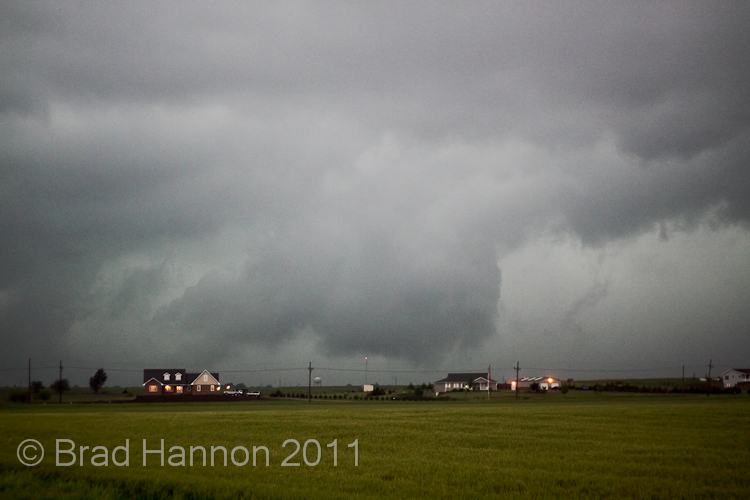
The structure on the nearby storm began to rapidly increase and the radar signature improved with inflow banding becoming more prominent and the base lowering. The next phase of the storm NE of Decatur TX involved the rotation of a rather tight base and wallcloud under it that resulted in a "Gonzo" like appendage.


The rotation of this wallcloud was very pronounced and warranted a spotter network report. Unfortunately, the anemic surface shear meant that the relatively high based storms were never going to become tornadic without some unusual interference. Typical of a storm in the LP spectrum, the storm looked fantastic for some time and then almost instantaneously evaporated. We then began to head to the original southern storm once more only to see it evaporate as well (it looks really quirky too, see the remnants of the storm rotate away into nothing after looking healthy minutes before). A new storm to our west near Jacksboro once again looked to be forming and rotating nicely on radar.


As we continued to move west the remnants of the storms behind became quite photogenic which had Crikey hanging out there.

 
The storm continued to look fantastic but we knew it was a race against time and that the storm would probably do the same thing as the first two.


As expected, as soon as we got into nice position on the storm the daytime heating began to dwindle, and the storm became a weak rotating element of its former self with a very narrow rotating updraft.


As the sun set the colours really picked up and left us with some really nice memories of a good if not slightly tough days chasing, our last for several days as a ridging high pressure pattern resumed.


Stay tuned for around Wednesday the 18th when the convection returns to the plains and the chase continues! Video snippets will be coming as soon as we manage to argue down the footage to a reasonable sample ;).

Feathers and Crikey


May 11 - You're targetting where?

So very little was happening on May 10 in a reachable location (unless you wanted to drive to western Minnesota), so we used this day to position from Kodoka SD to Salina KS, in anticipation of a dryline/triplepoint chase in Kansas the following day. Feathers was looking considerably worse for wear from jetlag and slept most of the way although I suspect he just didn't want to drive! Fortunately under threat of 'better or bullet' he picked up the next day in time for what was purported to be a moderate risk.

Come the morning of the 11th of May, unexpected convection fired prematurely in the TX panhandle and prompted the National Weather Service to douse the risk of severe weather to 'slight risk'. Our target was the warm frontal/triple point and so we headed for western Kansas near Quinter (recently famous for the 2008 wedge tornado), despite a few people we know asking "you're targetting where?".

We managed to get a severe warned multicell near Hays Kansas on the way out from the morning convection and held like many chasers for several hours as we waited for the weather to recover.  By late afternoon it was clear the warm front was only going to fire closer to the triple point, so a quick hours drive west put us on the second storm which formed and was severe warned near Burlington. As we approached on the interstate we could see the storm structure emerging and knew this baby was gonna rotate!


Our first view into Burlington was large hail falling and a funnel near the RFD, just to our west golfballs were reported, and we encountered similar size though fortunately they were soft. Mostly the hail was 2-3 centimeters. We were forced to punch first east through the edge of the RFD to get a suitable road network, and then east to get back on the right side of the storm which was elongating to the north. As we punched back east, there was a rotating lowering above our heads.

May 9 - First Chase Day

Hi folks, sorry for the delays, normal service will resume now that we are not covering 500+ miles a day. Very odd little system which caused us to run around a lot.

So as it goes with chasing May 8 turned out to be terribly boring, unfortunately it was pretty much a bust for chasers throughout Nebraska with only a single cell firing north in South Dakota (SD) out of our feasible range on our arrival day. We used it as an opportunity to position from Denver after the long Sunday journey over and we headed for Valentine, Nebraska.


Our first chase day began on the 9th May in Valentine where we enjoyed a surprisingly good breakfast at the hotel before filling up the oversized, gas guzzling top of the range rental (thanks for the upgrade!) and watching the Tornado Intercept Vehicle (as seen on TV) roll past us as the only other car on the road after a trip to the car wash. We made our way to Murdo, SD and encountered the chaser circus (Including Reed Timmer and the Dominator, chase tour groups, Verne Carlson, Mike Umschied just to name a few) as a relatively tight slight risk threat area was present to the west.

As the day went on the tornado probabilities bounced up and down, but the cap stubbornly refused to break. While the herd continued to hang in Murdo we decided to position NW from our location and noticed storms beginning to fire near Philip, South Dakota (while the vast majority of chasers were heading south to fruitlessly intercept the first storms which fired in northwest Nebraska, most didn't make it and busted).

The tail end and easternmost of these cells fired and sure enough began to rapidly escalate in the increasingly favourable environment with the potent low-level jet. A storm rapidly intensified to our south east and we quickly found ourselves on the wrong side of a storm that was becoming increasingly the classic supercell and little option with the road network given the storm motion. Shortly before this scan we were located at the little hail icon you can see on the radar display (John's report to spotternetwork of observed 2" (5cm, bigger than golfballs folks) hailstones, which sent us scurrying west.
The problem wasn't that we weren't going to beat the now tornado warned right mover before it crossed, but a left moving partner which had remained attached before disappating as the storm increased in strength.
As we ran back east now the hail had cleared, the light was quickly fading and making photographs hard (very late initiation), but there was plenty of video of hail falling and lightning illumnation of the storm. We did manage to get the photo above of the rear structure of the storm at the tornado warned stage, and what appears to be a funnel (no way to even suggest anything else).


As darkness descended and the storm moved N with a NE turn we positioned ourselves east of the hook and waited for lightning to illuminate any features.  We began to get hit by strong RFD winds and moved south to allow the circulation to pass as the features weren't visible enough.

The storm continued to show a beautiful radar signature, and shortly after produced a tornado in the dark north of Philips (which nearly took out a chaser who was playing with fire by chasing in the dark too close in when the tornado moved east to west in front of his car). All in all not a bad days chasing, just disappointing the cap took so long to be overcome, but we managed to avoid a bust along with the 3 other chasers on this storm.

And a short video of some of the better moments from the chase.

Full chasing videos will be available on the 2011 Hunters of Thunder USA Storm Chasing DVD available after we return.

Feathers & Crikey

Welcome Aboard, It Begins

Hey folks,
A warm welcome to all of you following and those who are lurking out there. You know who you are. Feel free to pass on the website address if you think others you know would be interested to follow this as I can guarantee the great plains will deliver. And it looks like delivery will begin straight away with a slight risk issued by the NWS for the potential target area.

Current indications are for a 500 mb shortwave trough to develop over the coming days with a weaker shortwave ejection occuring on Sunday. This is going to have a couple of effects on the plains: Induce height falls (because of overlying cold air, cold air doesn't take up so much room) in the North, and in the Southern plains (the area in Oklahoma/Texas) which will see storms develop along the classic dryline scenario:

Notice the steep gradient in dewpoint temperature that extends across Oklahoma, Kansas and Texas? Thats what we are looking for, if you see it on the plains the air to the east is muggy and murky while the air is dry to the west, its a really sharp boundary that you can cross in less than a kilometere. With ample shear this southern zone might prove quite active on Sunday.

But what about that other area? The moisture is wrapping around a forming low pressure system, generating a small buldge in the dryline. Along this the weak shortwave will come into play and generate Convective Available Potential Energy (CAPE) to 2500 which is quite unstable (not for the plains though) and steep lapse rates along with reasonable shear should see supercells with very large hail and possibly a few tornadoes.

So the question leading up to  this is South or North? Or somewhere completely difference (Central KS for instance). Only time will tell.

Crikey