After dropping a subdued John at Denver airport and checking the models and SPC forcasts, it was very clear I would be targetting the front ranges of Colorado the next day so I headed for Fort Morgan for the night and some Chinese fried rice with cashews.
The morning of the 6th saw me in a 5% tornado risk area before I even got out of bed! There was a Denver cyclone developing and combined with upslope flow and the potential for storms to fire off both the Palmer Divide and the Cheyenne Range, the day was looking full of promise.
So, as you do when you are already in your target area at 10am, I headed off for fuel, food and a Maccas to pass the time until storm initiation. After several hours of not seeing any other chasers in town, the convergence began including several doppler on wheels radar units and research teams.
Eventually storms fired to the west nd were moving slowly NNE. I held back within view and watched radar as others raced north but I was unimpressed by the storm motion and what I was seeing. I was waiting for a right mover or a cell to break away from the NNE motion and feed on the easterlies being pulled in by the Denver cyclone.
After following the initial cells slowly north I decided that the only sure bet for supercells this day would be to take a punt on cells developing an hour or so south off the Palmer Divide so I turned my attention that way and drove south for an hour.....and what a decision! As I approached my revised target area and had a slowly south moving storm in view, I was alerted to a tornado warning to my SW near the southern outskirts of Denver and another chaser convergence was underway including the Dominator tornado intercept vehicle and support vehicles.
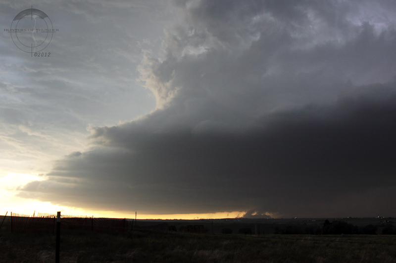
Soon I was in position to see the solid base features and dynamic nature of this supercell which persistently produced funnels and lowerings on the forward flank as it was really getting ramped up. I captured a possible brief and distant tornado (perhaps a landspout) in this early stage as the storm structured up, developed a long inflow tail from the east and went nuts on the moist easterly inflow.
 |
| The first view as I head south onto the near stationary supercell with solid RFB and forward flank lowering. Photo: Brad. |
 |
| This possible tornado (or landspout) was persistent & one of several early features on the forward flank of this storm. Photo: Brad. |
Not long after I noticed a large wall cloud area organising to my west and a clear slot was evident cutting around it.
 |
| Structure! The storm was barely moving but had impressive inflow from the SE as a wallcloud forms. Photo: Brad. |
Sure enough, a tall elephant trunk tornado formed right next to the wall cloud (but not from it) and was on the ground for over 5mins. Interestingly, as the tornado roped out and lifted the wall cloud area seemed to grow larger, take on a cone shape and lower toward the ground. To me it appeared to be a large cone tornado and perhaps even a wedge. To further enhance my thoughts on this being another tornado, the entire area finally lifted and what I thought initially was a wall cloud went through a significant rope out and I have never seen a wall cloud rope out before........... interesting.
The storm produced tornadoes, flash flooding and then simply ridiculous amounts of hail as it moved ever so slowly over the next few hours.
 |
| A tornado is forming as a clear slot cuts around the dark wall cloud area. Photo: Brad. |
 |
| A tall elephant trunk tornado persisted for over 5mins to my west as I was driving south for position. Photo: Brad. |
 |
| The tornado begins to rope out but is still quite large while the clear slot is cutting further around the adjacent wall cloud. Photo: Brad. |
 |
| Spectacular structure as the entire wall cloud area is now roping out which leads to a few questions..... Photo: Brad. |
 |
| Wow! Mammatus clouds on the forward flank of the storm were persistent like this for over half an hour! Photo: Brad. |
 |
| Large areas of dust/dirt were lifted into the storm base to my west. In this case a large funnel is curving back into the storm. Photo: Brad. |
I eventually core punched the storm into southern Denver and had fun with the crazy hail drifts for a few hours before chasing a new tornado warned storm through the SW suburbs at midnight! I saw the wallcloud and obvious signs of rotation on this storm lit up by city lights and constant lightning before this storm turned into yet another slow moving hail machine that turned the suburbs into a land of white ice like i've never seen before. At one stage as I core punched the hailer through a technology and business park, I came across rescuers who were pulling other cars out of several metres depth of ice and they told me they had already rescued 7 others. There was nothing I could do to help as the roads around me became rivers so I turned around and called it a night.
 |
| Later that night, Denver's SE was smashed by near stationary severe storms and ridiculous hail quantities. Photo: Brad. |
 |
| After chasing all day, how about a tornado warned storm in Denver at midnight?!?! Photo: Brad. |
A quick check of data for the next day showed that I wouldnt be going far. Could Colorado do it two days in a row? Of course it could! ........and even better :)


No comments:
Post a Comment