So finally we were looking at a day with a decent chance at tornadoes. A triple point (the intersection between a warm front and the dryline in this case) was poised to form in northern Kansas, with very potent rotation possible provided storms could make it through the cap. The Storm Prediction Centre stuck to a 5% tornado risk, but noted the probability was much higher in the vicinity of the triple point. Our target was Great Bend, KS with an expectation that storms would form slightly to our NW.
As others struggled to make it back from Wisconsin the day before we had a nice breakfast and a leisurely drive west to Great Bend from Ottawa KS and then waited, chatting to other chasers who had begun to converge on the sweet spot. It took some time for storms to form, but around 5 pm local time the first cell popped and then exploded, hitting 42,000 feet in less than 5 minutes in an environment of 4000 J/kg of CAPE. It took some time to form up and push even higher into the mid-50 thousands, but by the time we had closed on the cell it had rapidly developed low level inflow and a rather interesting wall cloud.
 |
| The first supercell of the day with wall cloud and low level inflow tail lifts dust as we close in. Photo - Brad. |
The cell seemed to struggle with the whole rotating wall cloud concept, with stronger mid level rotation, but many small points of rotation in the lower part of the cell. It also produced a very interesting outflow/RFD surge which kicked up tall jets of dust into its inflow and produced a large number of gustnadoes, several particularly strong and this coincided with a tornado report.
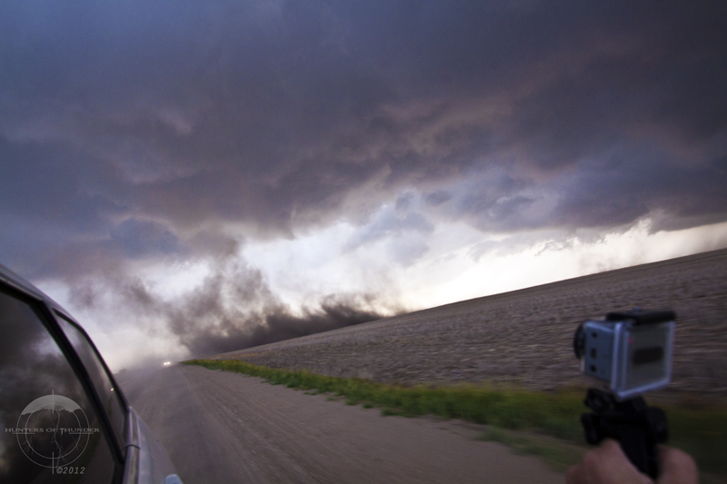
 |
| The dust machine is ramping up behind us as photography skills are taken to another level! Photo - Brad. |
 |
| An unusual feature that was reported as a tornado by other chasers, but may have been a stretching of the spin-up vorticity, illustrated by the vortices within the dust. Photo: John |
 |
| More evidence of the strength and vorticity in this feature. Could this be a non-supercellular tornado? Photo - Brad. |
Although the cell was looking nice in terms of structure and putting on a dust show like no other, it didn't quite look like it was going to be tornadic at this point. Two other cells had formed to the southwest and eventually we decided to drop onto the next cell and its accompanying wall cloud. We quickly closed again as there were reports of a tornado (unconfirmed) and were treated to a barrage of clean killer CG strikes from the anvil (including one that hit the powerlines 15m away) as the cell intensified before wrapping its wall cloud into the precipitation.
 |
| An unconfirmed tornado was reported while the lightning barrage was incredible on this new supercell. Photo - Brad. |
We repositioned while the storm was cycling a new wall cloud and then observed the circulation increase, produce a rotating funnel and then quickly occlude.
 |
Rapidly formed funnel cloud from an occluded wallcloud area. Photo - Brad.
|
However the show was only just beginning as we moved our attention to the next wall cloud. It began to strongly rotate, dropping an impressive cone which quickly became a beautiful tall elephant trunk tornado, back lit by the setting sun.
 |
'Tornadic Tail' - The tornado extends down from the mesocyclone with a long tailcloud extending to the right. Photo: John
 |
| Classic Kansas tornado with sunset. Photo - Brad. |
|
 |
'Fat Trunk' - The tornado develops an interesting phase with a thick moisture sheath extending high into the storm while pushing southwards. Photo: John
|
 |
| 'Elephant Trunk' - After shedding its sheath of fractus, the tornado elongates taking on a classic elephant trunk structure. Photo: John |
 |
| What a show! The tornado appears to have swallowed its prey as it bulges out as it rotates. Photo - Brad. |
The tornado transitioned towards a long horizontal rope phase and pushed southwards from the circulation, and appeared to weaken and begin to disappate, only to suddenly re-intensify and extend even further while drilling into the ground.
 |
'Kansas Rope' - The tornado begins to rope out and drill into the surface, or does it? Photo: John
|
 |
| The tornado is still in contact with the ground despite the condensation being cut further up, and up, and up... Photo - Brad. |
This show went on for several more minutes as the tornado eventually roped out and our attention turned to a new wall cloud in front of us that would go on to produce several tornadoes after dark including one that would hit part of the town of Russell.
<To be continued in Part 2: Monsters in the Night>


No comments:
Post a Comment